


20230809 Mouthiers au perche

Jeanclaudebic
User
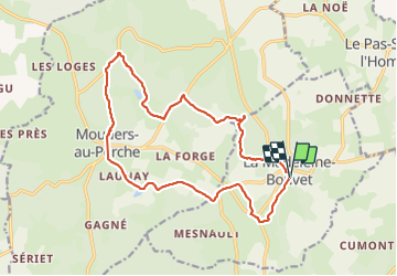

Length
16.6 km

Max alt
238 m

Uphill gradient
338 m
Km-Effort
21 km

Min alt
144 m

Downhill gradient
337 m
Boucle
Yes
Creation date :
2023-08-09 08:51:20.701
Updated on :
2023-08-09 14:29:00.424
5h23
Difficulty : Very difficult

FREE GPS app for hiking
 SityTrail
IGN / Geographical institutes
SityTrail Plus
The world is yours!
About
Trail Walking of 16.6 km to be discovered at Normandy, Orne, La Madeleine-Bouvet. This trail is proposed by Jeanclaudebic.
Positioning
Country:
France
Region :
Normandy
Department/Province :
Orne
Municipality :
La Madeleine-Bouvet
Location:
Unknown
Start:(Dec)
Start:(UTM)
344994 ; 5370628 (31U) N.
Comments